The Nazca Lines
Over 1,300 kilometers of art that can only be seen from the sky—created by people who couldn't fly
The Scale
"The Nazca Lines are among the most striking archaeological anomalies in the world. Their purpose remains one of the great unsolved puzzles of South American archaeology."
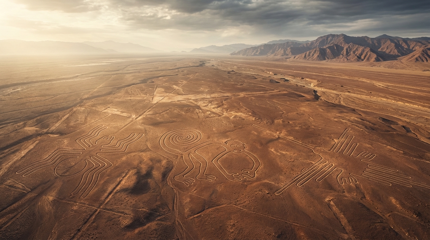
— Maria Reiche, mathematician and Nazca Lines researcher, lifetime study 1946–1998Spread across roughly 450 square kilometers of arid Peruvian desert, the Nazca Lines comprise more than 1,300 kilometers of lines, 300 geometric figures, and over 70 biomorphs—animal and plant designs—some stretching up to 370 meters (1,200 feet) in length. They were created between approximately 500 BC and 500 AD by the Nazca culture, who removed the reddish surface pebbles to expose the lighter ground beneath.
The figures include a spider, a hummingbird, a monkey, a condor, a whale, a dog, and dozens more. The geometric lines are ruler-straight, some extending for kilometers across hills and valleys without deviation. The precision is remarkable: modern surveys have confirmed that the lines maintain their straightness over distances where the curvature of the earth would introduce visible error without careful surveying techniques.
The Visibility Problem
"You cannot appreciate a single one of the figures from ground level. It is only from the air that their full shape becomes apparent. This has always been the central paradox of the Nazca Lines."
— Paul Kosok, American historian, first systematic aerial survey, 1941Here is the fundamental question that has driven Nazca research for nearly a century: the biomorphs are only recognizable from the air. From ground level, you see nothing but lines in the dirt. The hummingbird, the spider, the monkey—their shapes are invisible to anyone standing on the desert floor. They were designed to be seen from above.
The Nazca people had no aircraft, no hot air balloons (despite some creative theories involving smoke-filled reed balloons), and no tall structures from which to observe their work. They created art on a scale visible only to the gods—or to someone, something, that could see from the sky. Maria Reiche, who devoted her entire life to studying the lines, believed they were a giant astronomical calendar. Others have proposed they were sacred pathways walked during religious ceremonies. But neither theory fully explains why the designs needed to be recognizable from altitude.
The Precision
"The geometric precision of the Nazca Lines implies a level of mathematical and surveying knowledge that we would not expect from a pre-literate society without metal tools."
— Anthony Aveni, Between the Lines: The Mystery of the Giant Ground Drawings of Ancient Nasca, Peru, 2000Researchers have demonstrated that it is possible to create the Nazca Lines using only stakes, cord, and careful planning. Joe Nickell famously recreated a small Nazca-style figure using simple tools in 1983. But "possible" and "easy" are different things. The Nazca people maintained geometric precision across distances of several kilometers, created perfectly proportioned animal figures at enormous scale, and did it all in a desert with no water sources and extreme heat.
The sheer labor involved is staggering. Researchers estimate that the lines required hundreds of thousands of person-hours to create. This wasn't a weekend project. It was a multi-generational, culture-defining obsession. The Nazca people devoted an enormous portion of their society's resources to creating art that none of them could ever fully see. That level of commitment demands a powerful motivation—more powerful, perhaps, than a simple astronomical calendar.
Recent research using AI-assisted image analysis has identified hundreds of previously unknown smaller geoglyphs, many depicting human figures and decapitated heads—suggesting a connection to Nazca headhunting rituals and ancestor worship. In 2019, a Japanese team from Yamagata University discovered over 140 new geoglyphs using satellite imagery and machine learning, nearly doubling the known count.
The water table theory, proposed by David Johnson and developed by researchers at the University of Massachusetts, suggests the lines map underground aquifers—the puquios, or underground aqueduct system, that the Nazca relied on for survival in one of the driest places on Earth. Some of the geometric lines do appear to correspond to fault lines and water sources. But this theory doesn't explain the biomorphs.
What haunts the imagination about Nazca isn't any single theory. It's the collision of facts that don't fit together comfortably. A pre-literate society with no metal tools achieved geometric precision that rivals modern surveying. They created art at a scale only appreciable from altitude they could not achieve. They devoted generations of labor to this effort. And we still don't know why.
The Nazca Lines are not a mystery of "how"—we can explain the methods. They are a mystery of "why"—and that may be the deeper question.
Sources & Further Reading
- Reiche, Maria — Mystery on the Desert (1949, revised editions through 1993) — see also Maria Reiche (Wikipedia)
- Aveni, Anthony — Between the Lines: The Mystery of the Giant Ground Drawings of Ancient Nasca, Peru (2000)
- Kosok, Paul — "The Mysterious Markings of Nazca," Natural History (1947) — see also Nazca Lines (Wikipedia)
- Masato Sakai et al. — "AI-Accelerated Nazca Survey," Proceedings of the National Academy of Sciences (2022)
- Nickell, Joe — "The Nazca Drawings Revisited," Skeptical Inquirer (1983)