Atlantis & the Eye of the Sahara
What If Plato Was Describing a Real Place?
Plato’s Account
“There was an island situated in front of the straits which are by you called the Pillars of Heracles; the island was larger than Libya and Asia put together… Now in this island of Atlantis there was a great and wonderful empire which had rule over the whole island and several others, and over parts of the continent.”
— Plato, Timaeus, c. 360 BCE (translated by Benjamin Jowett)Around 360 BCE, the Greek philosopher Plato described Atlantis in two dialogues — the Timaeus and the Critias. The account was presented as history, not fiction, passed down through the Athenian statesman Solon, who had heard it from Egyptian priests at Saïs. Plato placed the destruction of Atlantis approximately 9,000 years before Solon’s time — roughly 9600 BCE, which aligns precisely with the end of the Younger Dryas cataclysm. This is either a remarkable coincidence or evidence that the dating should be taken seriously.
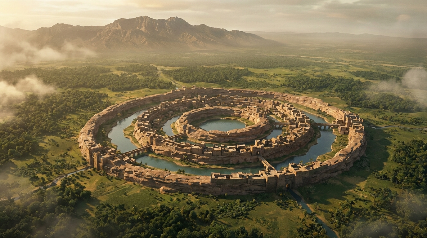
Plato’s description was unusually specific. Atlantis was situated “in front of the Pillars of Heracles” (the Strait of Gibraltar). Its capital city was built on a hill surrounded by alternating rings of water and land — two rings of water separated by three rings of land, with a central island. The outermost wall was coated in brass, the second in tin, and the innermost “flashed with the red light of orichalcum.” Hot and cold springs issued from the central island. The city faced south, with mountains to the north sheltering it from cold winds. And its dimensions were given: the central island was approximately 5 stadia (about 925 meters) in diameter.
The Richat Structure
“The Richat Structure is a prominent circular feature in the Sahara desert of west-central Mauritania. It has a diameter of approximately 40 kilometers and is composed of concentric rings of resistant quartzite ridges separated by valleys of less resistant rock.”
— Guillaume Matton & Michel Jebrak, “The Richat Structure as a Terrestrial Analog for Martian Plateaus,” Earth Science Reviews, 2014The Richat Structure — also called the Eye of the Sahara or the Eye of Africa — is a 40-kilometer-wide geological formation in the Adrar Plateau of Mauritania, West Africa. Visible from space, it consists of concentric rings of alternating ridges and valleys, centered on a dome of uplifted sedimentary and igneous rock. For decades it was dismissed as either an impact crater (no shock metamorphism was found) or a simple geological dome (which doesn’t fully account for its perfect concentricity). Current geological consensus calls it a “deeply eroded structural dome” — but the mechanism that produced such perfect ring symmetry remains debated.
The Richat Structure sits in northwest Africa, directly south of the Strait of Gibraltar — in front of the Pillars of Heracles. Its concentric rings of ridges and valleys mirror Plato’s description of alternating rings of land and water. The central dome measures approximately 900 meters across — close to Plato’s stated 5 stadia. The formation opens to the south, toward the Atlantic coast, matching Plato’s note that the city faced the sea to the south. Mountains lie to the north. The coincidences accumulate.
The Sahara Was Green
“During the African Humid Period, approximately 11,000 to 5,000 years ago, the Sahara supported lakes, rivers, grasslands, and human populations. The region that is now hyperarid desert was a habitable, well-watered landscape.”
— Peter deMenocal et al., “Abrupt onset and termination of the African Humid Period,” Quaternary Science Reviews, 2000The objection is immediate: Atlantis can’t be in the Sahara because the Sahara is a desert. But this objection assumes the Sahara has always been a desert, and it hasn’t. During the African Humid Period (also called the Green Sahara), roughly 11,000 to 5,000 years ago, the entire region experienced dramatically higher rainfall. Satellite imagery and geological surveys have revealed the ghosts of vast river systems, enormous lakes (including a “Mega-Chad” that was the size of the Caspian Sea), and evidence of widespread human habitation. Rock art from the Tassili n’Ajjer plateau in Algeria depicts cattle herding, swimming, and boats — in a region where no water has flowed for thousands of years.
The Richat Structure during this period would have been a dramatically different landscape. Water would have filled the ring valleys. Rivers flowed through what is now barren rock. The concentric rings of the structure, currently dry ridges and empty trenches, would have been exactly what Plato described: alternating rings of land and water surrounding a central island. The timeline also fits — the Green Sahara period overlaps with Plato’s stated timeframe for Atlantis, and its abrupt termination around 5,500 years ago would have turned any civilization in the region to dust and sand within centuries.
The Dimensions
“The whole country was said by him to be very lofty and precipitous on the side of the sea… The plain surrounding the city was enclosed by mountains which descended towards the sea; it was smooth and even, and of an oblong shape, extending in one direction three thousand stadia, but across the centre inland it was two thousand stadia.”
— Plato, Critias, c. 360 BCEResearchers who have mapped Plato’s measurements onto the Richat Structure find a troubling number of correspondences. The central island diameter: approximately correct. The ring pattern: concentric alternating ridges and valleys, as described. The orientation: opening south toward the sea (the Atlantic coast is roughly 500 km to the west-southwest). Mountains to the north: the Adrar Plateau. The plain extending south from the city: the flat terrain of southern Mauritania stretches in the dimensions Plato specified. Even the mention of red, white, and black stone in the construction of the city walls corresponds to the geology of the Richat Structure, which contains bands of red sandstone, white limestone, and dark volcanic rock.
None of this constitutes proof. The Richat Structure has not yielded archaeological artifacts consistent with an advanced civilization. No walls, no harbor infrastructure, no orichalcum. But the geological time that has passed — at minimum 5,000 years of hyperarid desert conditions, with scouring winds, sand burial, and flash erosion — would be sufficient to destroy most evidence of human construction. What survives in the Sahara from that era are cave paintings and stone tools. Anything built from quarried blocks, metal, or wood would be long gone.
The Atlantis question has haunted Western civilization for 2,400 years. Hundreds of proposed locations have been offered — from Santorini to Antarctica, from the Azores to Indonesia. Most fall apart under scrutiny because they fail to match Plato’s specific geographic and dimensional details. The Richat Structure is unusual among candidates because it matches so many of them simultaneously: the concentric rings, the dimensions, the cardinal orientation, the geology, the proximity to the Pillars of Heracles, and the timeline.
The mainstream archaeological position is that Atlantis was a philosophical allegory — Plato’s way of illustrating the hubris of empires and the fragility of civilization. This interpretation has merit. Plato was a philosopher, not a historian, and the Atlantis narrative served his philosophical arguments perfectly. But Plato explicitly states, through the character of Critias, that the account is “not a fiction but a true story.” He attributes it to Egyptian priests with records going back thousands of years. He provides measurements, materials, geographic coordinates, and a specific timeline. If this is allegory, it is the most meticulously detailed allegory in the history of philosophy.
The Younger Dryas connection adds another layer. Plato dates the destruction of Atlantis to approximately 9600 BCE — the precise onset of the Younger Dryas cataclysm. If the Richat Structure was the site of a thriving civilization during the Green Sahara period, its destruction could have come in stages: first the climatic upheaval of the Younger Dryas, then the slow desiccation as the African Humid Period ended thousands of years later, burying whatever remained under meters of sand.
The Eye of the Sahara theory was popularized by independent researchers and YouTubers in the late 2010s, and it has been dismissed by most professional geologists and archaeologists. The dismissal is reasonable — there is no hard archaeological evidence, and the geological formation has a natural explanation (however incomplete). But the dismissal also carries a certain circularity: no one has conducted a systematic archaeological excavation of the Richat Structure’s central dome or ring valleys. The absence of evidence, in this case, may reflect an absence of investigation rather than an absence of artifacts.
Plato told us where it was. He told us what it looked like. He told us when it was destroyed. There is a formation on Earth that matches his description in ways no other candidate does. Whether that formation is the remains of a lost civilization or the geological coincidence of the millennium is a question that can only be answered by digging. So far, no one has.
Sources & Further Reading
- Plato — Timaeus and Critias (c. 360 BCE, translated by Benjamin Jowett)
- Matton, Guillaume & Jebrak, Michel — “The Richat Structure as a Terrestrial Analog,” Earth Science Reviews (2014)
- deMenocal, Peter et al. — “Abrupt onset and termination of the African Humid Period,” Quaternary Science Reviews (2000)
- Richat Structure — Geological Survey of Mauritania field reports
- Zhangyu Sun et al. — “Formation of the Richat Structure,” Journal of African Earth Sciences (2006)
- Bright Insight (YouTube) — “Atlantis is the Eye of the Sahara” (2018, popularized the theory)
- Hancock, Graham — Fingerprints of the Gods (1995) and Magicians of the Gods (2015)